Showing posts with label Tertiary Piedmont Basin. Show all posts

Wednesday, May 5, 2021

Rocks and soils of Timorasso's Colli Tortonesi DOC

I have previously treated the geology of Colli Tortonesi DOC but, while the treatment was comprehensive, the final product was unconsolidated. I address that shortcoming in this post.

The Villalvernia-Varzi Line is a key feature of the regional geology. It is an east-striking, slightly dipping fault zone which separates the sedimentary structures of the Tertiary Piedmont Basin to its south of from the Epiligurian Unit sediments in the wedge-top basin to its north. The role that this line has played is evidenced in the two charts following which show the comparative parent-rock geology. The Line is represented by the Antognola Formation in both of the charts.

In the charts below, we see evidence of at least four tectonic events south of the line and no equivalent activity in the north.


The chart immediately following shows a lack of alignment in sediment deposition within the two basins except for Sant'Agata Marl in the middle of the Late Miocene and no evidence of deposition in the Epiligurian Units post that phase. It is unclear as to whether that lack of deposits post the Sant'Agata phase was due to erosion in the Epiligurian column or an early uplift.

Screen shot from Festa, et al., 
Geological Map of the Villalvernia-Varzi Line

As shown in the chart below, the parent rocks have eroded down to primarily limestone, clays and marls. 


Descriptions of these soil types can be found on my soils page but I have also used the wein+ glossary to construct the table shown below.

Table 1. Soil types described in Colli Tortonesi (Descriptions curated from Wein+)

Soil Type

Description

Limestone

  • Rocks with a dominant proportion of calcium carbonate and smaller proportions of magnesium carbonate
  • Widespread asa light grey or yellowish mineral and sedimentary rock
  • Formed as sedimentary rock in the sea by deposition of calcareous shells and skeletons of small marine animals and as lake sediment
  • Iron poorly available to plants in calcareous soils
  • Usually yield wines with good acidity; particularly well-suited to white wine varieties
  • Appreciated in cooler wine growing areas but require lime-tolerant rootstocks

Chalk

  • White, soft, fine-grained limestone that breaks down into a white powder
  • Often contains flint
  • Good water drainage due to its great porosity
  • Soil easily penetrable by vine roots

Clay

  • A mixture of sand, silt, and clay
  • Depending on the ratio, distinction made between sandy, silty, or clayey loam
  • Colored yellow=brown by iron compounds
  • Usually already decalcified
  • Produces full=bodied, powerful wines

Marl

  • Grey or yellowish sedimentary rock of about half clay and half limestone
  • Formed where clay particles were deposited on the fossil seabed with simultaneous lime precipitation
  • Fertile, heavy soils with high pH values

Sand

  • Weathering products of hard rocks
  • Grain size between 63 micrometers and 2 millimeters
  • High proportions of quartz and feldspar
  • Water-permeable, dry, and often infertile
  • Produces fragrant, low-acid wines

Lime Tuff

  • Deposition of lime with air inclusions
  • Porous structure caused by swelling mosses on whose plant  bodies lime precipitates
  • Mosses eventually calcify and die, while new mosses are already growing above them

©Wine -- Mise en abyme

Saturday, April 17, 2021

The Geology of Timorasso's Colli Tortonesi DOC

The most recent activity in European mountain-formation began with the initial compression caused by subduction of the European plate under the African plate in the Jurassic period. Collision between the African and Eurasian plates resulted in increased deformation of Tethyian Sea deposits. The orogeny "produced intense metamorphism of preexisting rocks, crumpling of rock strata, and uplift accompanied by both normal and thrust faulting." Remnants of the Tethys Sea remain as the Mediterranean, Black, Caspian, and Aral Seas. The plate movement resulted in the Italian peninsula being driven northward and compressed into Europe.

At the "conclusion" of the Alpine orogeny, the area that is now Colli Tortonesi did not exist in its current form; rather, it was the eastern portion of a basin that rested beneath a remnant of the Tethys Sea -- the Tertiary Piedmont Basin (TPB) -- separated from another wedge-top basin -- the Epiligurian Succession -- by a tectonic fault called the Villalvernia-Varzi (VV) Line. Colli Tortonesi is roughly positioned on the sketch map below. I discuss the basement, the VV fault, and the successions in the material following. 


The Colli Tortonesi Basement
In the Oligocene - Miocene, Ligurian Units, comprised of fragments of the Ligurian-Piedmony Ocean basin and the transition zone to the Adria continental margin, was carted onto the more external domains corresponding to the continental margin of Adria (Tuscan-Umbrian domain). The resulting structure is illustrated in the chart below.


The figure shows the Villavernia-Vernia Line, a prominent feature throughout the entire basement profile. As shown in the figure, VVL separates the TPB from the Epiligurian Units.

Villalvernia-Varzi Line
The characteristics of the line are illustrated in the chart below.


Tertiary Piedmont Basin
As shown in the chart above, the TPB is located to the south of the VV Line.

Beginning in the late Eocene, the Tertiary Piedmont Basin (TPB) developed within the Epimesoalpine  Basin and "sealed the meso-Alpine deformations caused by various tectonic units ranging from the Ligurian Alps (Voltri Group, Brianconnais) to the Northern Apennines (Ligurian Units)." The TPB is divided into three sectors -- western (Langhe). central, and eastern (Borbera-Grue) -- by the Celle-Sandia and Sestria-Voltaggio fault lines. The sedimentary succession, and underlying basement rocks, are present in all three sectors, as shown in A below.

A - Deposits in the basin (Source: The Tertiary Piedmont
Basin, Mufti, et al.); B - Age ranges in the Stages of the Miocene
 (Source: Wikipedia); C - Composition and depths of Oligocene
and Miocene deposits (Source: Mufti, et al)

The TPB sedimentary succession began in the mid-Oligocene and continued through the Miocene. A (above) shows the population of sedimentations by geographic era while C shows the types and extent of sedimentation, exclusive of the Messinian period. The deposits through the Tortonian are predominantly terrigenous in nature -- that is, originating from land -- and are primarily sandstones and mudstones. At its deepest points the succession records a thickness of 6000 m (Mutti, et al.).

The Borbera Valley succession, the area of import for our purposes, is characterized by the sedimentary succession beginning with the Val Borbera conglomerates -- a 2500-m-thick layer of continental-to-marine conglomerates from the Lower Oligocene. In the Costa Merlassino area, Sandstone of Ranzano and Marls of Monte Piano are interposed between the Val Borbera Conglomerates and the Antola Unit. The Middle-Borbera-Valley succession is illustrated in the chart below.


The eastern (Borbera-Grue) sector:
  • Exposes the lowermost part of the sedimentary succession of the TPB (upper Eocene)
  • Experienced, during the Oligocene and Miocene, a major phase of subsidence, leading to the deposition of relatively deep-water turbidites
  • After the Burdigalian, and concurrently with a phase of dramatic inversion of the entire basin, experienced a progressive uplift expressed by a general shallowing upward of the depositional profile.
External Ligurian Units and Epiligurian Unit
Epiligurian Units are found in the wedge-top basin to the north of the VV Line and describes the deposits into that basin between the Middle Eocene and Middle Miocene. The succession is illustrated graphically below.


Quaternary Succession
Quaternary deposits are 2.5 million years old and younger. All of the Quaternary deposits found in the region are located along the valley floors, indicating river-driven migration.

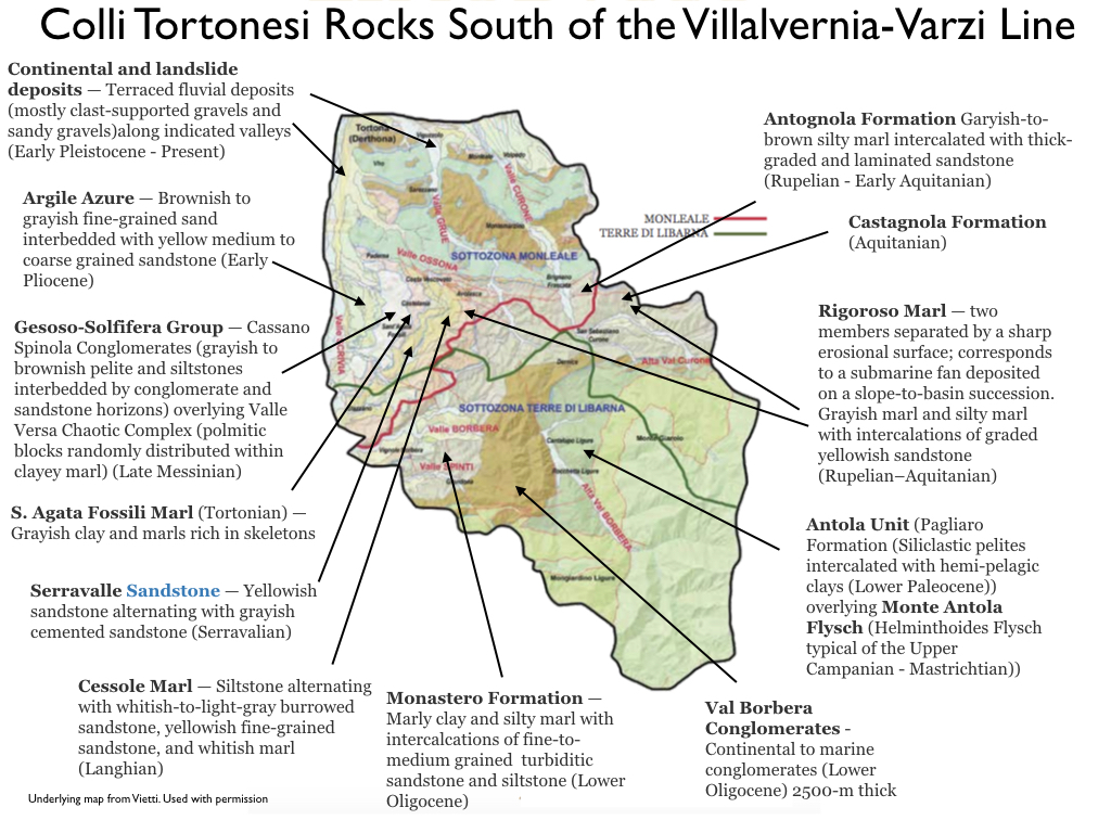
Quaternary soils in Colli Tortonesi
(Underlying map from Vietti. Used with permission)

Conclusion
The chart immediately below shows the distribution of rocks in the areas to the north and south of the Villalvernia - Varzi Line, inclusive. The chart indicates four distinct tectonic periods on the TPB-side of the line and "relative" calm in the area above. 


This chart summarizes the successions in the VVZ area and provides detailed descriptions of each rock formation encountered.

Source: https://www.unito.it/sites/default/files/temi_geologo_ii_2015_allegato1.pdf


©Wine -- Mise en abyme


Thursday, September 21, 2017

The Langhe Hills Landscape: The Messinian Salinity Crisis and the Tertiary Piedmont Basin

My previous post treated the Tertiary Piedmont Basin succession through the Tortonian. In this post I treat the sedimentation occurring during the Messinian period.

The Tethys Ocean separated Africa and Europe during the Jurassic and Cretaceous periods but was mostly eliminated as a result of the collision of the continents. Elements of this ocean survive today as the Mediterranean, Black, Caspian, and Aral Seas.
The Mediterranean Sea maintained its connection to the Atlantic and Indo-Pacific Oceans until early in the Miocene when it was reduced with the joining of the two continents along the Middle East front around 14 million years ago (mya). This joining of the two continents began a gradual change to a more arid Mediterranean climate.

The Mediterranean Sea connection to the Atlantic Ocean was maintained through various avenues (see figure below) until the closure of the Rifean Corridor in the early Messinian.


The closure of the Atlantic access precipitated a rapid environmental and climatic change driven by high evaporation rates in the Mediterranean Sea and the inability of riverine sources to replenish the water loss. This event is generally referred to as the Messinian Salinity Crisis and a rough timeline is as follows:

·       5.96 mya – Closure of the Rifean Corridor and partial dessication of the Red Sea
·       5.8 mya – Mediterranean almost dries out. Massive dessication leaves a deep, dry basin 3 to 5 km below sea level with a few hyper-saline pockets
·       5.5 mya – Less dry climatic conditions ensue resulting in more fresh water from the rivers. This fresh water progressively fills the basins and dilutes hyper-saline pockets into larger pockets of brackish water
·       5.33 mya – Zanclean flood. Strait of Gibraltar opens up, quickly filling the Mediterranean with water from the Atlantic Ocean. The end of the crisis.
As described in Progeo Piemonte (Climate variability and past environmental changes: lessons from the Messinian record of the Tertiary Piemonte Basin), “In less than a million years, deep sea sediments are replaced by shallow sea deposits, continental deposits, lacustrine sediments and eventually deep sea sediments.”
According to Nesteroff (The Sedimentary History of the Mediterranean during the Neocene), all of the Messinian deposits they encountered during their drilling explorations in the region “proved to be evaporitic species comprised of dolomitic marls interbedded with massive gypsum, anhydrite and halite.” On land, they found that, in the same period, The Tortonian blue marls were suddenly replaced by either evaporitic series or by lacustrine and continental deposits. The evaporitic deposits are primarily found in the deepest part of the sea but some fragments are found on margins that have been tectonically uplifted.
According to Progeo Piemonte, Messinian age rocks present in the Langhe describe a chronological sequence of the events associated with the Messinian Salinity Crisis:
·       Marls and Mudstones – rocks derived from deep sea sediments. These rocks record the alternation between a warm and humid climate and a cooler, less-humid one. Microfossils in the rock point to the exact moment when the Mediterranean weas cut off from the Atlantic.
·       Gypsum selenite and laminate – These minerals were formed in water with high salinity and point to an increased evaporation linked to the isolation of the Mediterranean Sea.
·       Sandstones and mudstones – Sediments deposited on the continent in low-salinity waters, rich in fossil vertebrate remains and shells of lacustrine molluscs. These remains testify to a savannah environment with temporary pools of fresh water.
·       Calcareous marl – These rocks tell the story of a re-established full connection between the Atlantic and the Mediterranean. These rocks are rich in marine planktonic microfossils recording a deep (around 800 m) marine basin.
·       Erosion surface – This surface describes an event of rapid dismantling of sediments caused by compressive tectonic forces.


©Wine -- Mise en abyme

Monday, September 18, 2017

Formation of the Langhe Hills landscape: The Tertiary Piedmont Basin

At the "end" of the Alpine orogeny, the area that is now the Langhe Hills did not exist in its current form; rather, it was a basin that rested beneath a remnant of the Tethys Sea. This basin -- the Tertiary Piedmont Basin (TPB) -- eventually became the repository for a sedimentary succession -- measuring 3000 sq km -- located at the junction between the southern section of the western Alps and the western termination of the northern Apennines (Mutti, et al., The Tertiary Piedmont Basin) and resting on wedges of both orogens. According to Mutti, et al., the basin rests on a segment of the wedge formed after the Alpine collosional event and was affected by the the growth of the Apennic orogenic wedge from the Oligocene on. Figure 1 below shows the TPB in relation to the major geologic structures of Northern Italy.

Figure 1. Structural sketch map of Northern Italy.
Source: Festa &Codegone, Geological Map of the 
External Ligurian Units ..., Journal of Maps 9, 2013.
The TPB is divided into three sectors -- western (Langhe). central, and eastern -- by the Celle-Sandia and Sestria-Voltaggio fault lines. The sedimentary succession, and underlying basement rocks, are present in all three sectors, as shown in Figure 2A below.

Figure 2: A - Deposits in the basin (Source: The Tertiary Piedmont
Basin, Mufti, et al); B - Age ranges in the Stages of the Miocene
 (Source: Wikipedia); C - Composition and depths of Oligocene
and Miocene deposits (Source: Mufti, et al)

Basement
The western sector basement rocks are Brianconnais units -- slices of European crust with a low-grade metamorphic imprint.

The central sector basement rock is of the Voltri Group, slices of oceanic suites composed of ophiolites (small pieces of oceanic crust that have been attached to the continent) and their sedimentary cover metamorphosed at high-pressure - low-temperature. This structure is generally credited with halting the eastern thrust of the Alps. The Sestri-Voltaggio line is the eastern boundary of the Voltri Group.

The eastern sector basement is comprised of Ligurian units, slices of oceanic suites composed of ophiolites and their sedimentary cover metamorphosed at low- to very-low-grade conditions.

Sedimentary Succession: Mid-Oligocene to Miocene
The TPB sedimentary succession began in the mid-Oligocene and continued through the Miocene. Figure 2A shows the population of sedimentations by geographic era while Figure 2C shows the types and extent of sedimentation exclusive of the Messinian period. The deposits through the Tortonian are predominantly terrigenous in natute -- that is, originating from land -- and are primarily sandstones and mudstones. At its deepest points the succession records a thickness of 6000 m (Mutti, et al.).

As the soils of note in the Barolo Zone derive mainly from upper layers of the succession, we will confine the discourse in this post to those layers. Mutti, et al., suggest that the depositional settings evolved as follows:
  • Western sector troughs infilled with mixed terrigenous systems delta-fed from the Western Alps (Cortemalia and Lequio Units)
  • A shallow-marine domain, primarily consisting of southerly fed delta systems (Cessole and Serravelle Units) developed in the central and eastern sectors of the basin
  • A progressive uplift of the eastern and central sectors leading to the final infill of the basin with widespread southerly derived deltaic strata (Serravelle Unit)
  • During the Tortonian, these deltaic sediments experience a sudden regional drowning resulting in the deposition of progressively deeper-water and finer-grained strata (Sant'Agata Fossili Marl) and, eventually, chaotic deposits, indicating a tectonically steepened slope environment
  • These finer-grained slope strata encase re-sedimented coarse-grained and channelized bodies (Vargo Units) which are overlain by mudstones that grade upward to euxinic (black carbon-rich) shales
  • The latter are overlain by Messinian evaporites (not shown in Figure 2C and to be discussed in a later post)
The closure of the Straits of Gibraltar led to the Messinian Unconformity signaling the end of the Oligocene-to-Miocene succession. I will cover the Messinian Salinity Crisis in a follow-up post.

©Wine -- Mise en abyme