Showing posts with label Soils. Show all posts

Thursday, June 25, 2020

Regenerative Agriculture: A soils-composition primer

Soil health, according to the USDA, is "... the continued capacity of soil to function as a vital living ecosystem that sustains plants, animals, and humans." Agriculture Victoria defines soil health as "... the condition of the soil in relation to its inherent (or potential) capability, to sustain biological productivity, maintain environmental quality, and promote plant and animal health."

Photo credit: USDA

Soil health is one of the key pillars of the Regenerative Organic Certification and a key objective of Regenerative Agriculture as a discipline. In order to fully understand the principles guiding the soil health requirement of Regenerative Agriculture, we need an understanding of soils. I present a soils primer in this post.

The essential functions of soils are (NRCS.USDA.gov):
  • Regulating water -- soil helps control where rain, snowmelt, and irrigation water go. Water and dissolved solutes flow over the land or into and through the soil
  • Sustaining plant and animal life -- the diversity and productivity of living things depend on soil
  • Filtering and buffering potential pollutants -- the minerals and microbes in soil are responsible for filtering, buffering, degrading, immobilizing, and detoxifying organic and inorganic materials, including industrial and municipal by-products and atmospheric deposits
  • Cycling nutrients -- carbon, nitrogen, phosphorous, and many other nutrients are stored, transferred, and cycled in the soil
  • Physical stability and support -- provides a medium for plant roots.
The major soil components are illustrated in the chart below and then detailed in the text following.

Approximate composition of soil
(Source: https://www.ctahr.hawaii.edu/mauisoil/)

Soil Components
Soil is comprised of air, water, mineral particles (a mix of clay, silt, and sand), organic matter (decomposing plant material), and organisms (bacteria, algae, fungi, earthworms, insects, etc.).

Soil Minerals
The earth is made up of varying proportions of the 90 or so naturally occurring elements but, according to Alex Maltman (Vineyards, Rocks, & Soils), four of these -- oxygen at 48%, silicon at 28%, aluminum at 8%, and iron at 6% -- are responsible for 88% of its composition. In most geological materials, these elements combine to form minerals -- "a naturally occurring combination of specific elements that are arranged in a particular repeating three-dimensional structure or lattice" (opentextbc.ca, Minerals and Rocks).

In nature, minerals are found in rocks "and the vast majority of rocks are composed of at least a few different minerals." The picture below shows a piece of granite and its constituent minerals.

A close-up view of the rock granite and associated minerals
(Source: opentextbc.ca)

Jackson (Wine Science: Principles and Applications) stipulates that (p. 245) "... the mineral content of soil is primarily derived from the parental rock substrate." Soil minerals play a vital role in soil fertility in that (i) mineral surfaces serve as potential sites for nutrient storage and (ii) the weathering of primary minerals yields smaller particles that we call soil as well as releasing nutrients into the soil. The figures below show the weathering of rocks into minerals.


Source: geology.csupomona.edu


Soil Organic Matter (SOM)
What is SOM? "The organic fraction of the soil that includes plant, animal and microbial residues in various stages of decomposition, biomass of soil microorganisms and substances produced by plant roots and other soil organisms."

The soil components chart above shows organic matter comprising approximately 5% of the total soil but it plays an outsize role in the health of the soil and the crops raised therein. The distribution of SOM components are shown in the chart below.

Approximate distribution of organic matter in healthy soils
(Source: nrcs.usda.gov)

SOM makes up a small portion of the overall soil but has an outsize influence on soil functions (see Table 1 below).

Table 1: SOM influences on soil functions
Soil Function SOM Influences
Water management
  • Helps soil create large pore spaces and channels that allow water to infiltrate and drain and small pore spaces that hold on to water
  • Residues on the surface protects the soil surface from atmospheric elements 
Soil structure
  • Plant exudates and microbial byproducts can be sticky substances that help soil particles held together to form and stabilize aggregates
  • Physical benefits of increased aggregation
    - Better aeration
    - Better friability (crumbly): ideal rooting medium for plants
    - Less crusting
       - Crusting prevents water and air movement into the soil
       - Can prevent seedlings from emerging
       - Promotes water runoff
  • Biological benefits of increased aggregation 
    - A home for soil microbes, worms, and insects
    - Food storage — organic matter incorporated into aggregates and slow-released 
Nutrient cycling and retention As soil organisms break down and decompose soil organic matter will be consumed by soil organisms and released into the soil solution
Cation exchange capacity (CEC)
  • CEC measures the soils ability to temporarily hold on to many cations
  • SOM provides between 20 and 80% of the CEC in mineral soils
Microbial diversity and resiliency
  • Organic matter is the main food source for many organisms in the soil
  • Organic matter helps to create a mix of conditions and variety of homes to support the diversity that we rely on 

Living Organisms
The soil food web is the community living all or part of their lives in the soil. The food web diagram below shows a series of conversions of energy and nutrients as one organism eats another.

Source: https://www.nrcs.usda.gov/wps/portal/nrcs

"As organisms decompose complex materials, or consume other organisms, nutrients are converted from one form to another, and are made available to plants and to other soil organisms. All plants -- grass, trees, shrubs, agricultural crops -- depend on the food web for their nutrition ... By-products from growing roots and plant residue feed soil organisms. In turn, soil organisms support plant health as they decompose organic matter, cycle nutrients, enhance soil structure, and control the population of soil organisms, including crop pests" (NRCS.USDA).

The fuel for the food web is the SOM discussed above.

Soil Water
Half of the overall soil content is pore space, a 50-50 mix of air and water.

Through the process of transpiration, water serves as a vehicle for moving material into, within, and out of the vine plant.  Water enters a vineyard through precipitation or irrigation and that water either runs off, flows to levels beyond which it can be accessed by the vine plant, or remains in the rooting zone where it is available for the plant's use. The plant uses water as an internal distribution vehicle (in addition to other functions) and facilitates this by expelling water through pores (stomata) in the leaves.  As water is transpired from the leaves, replacement water is drawn in at the roots.

Source: talktalk.co.uk

Water attracted to the vine root by transpiration moves undiluted nutrients to the root surface (bulk flow) but also carries dissolved nutrients into the roots as a part of its transit. Nitrogen is the nutrient most frequently acquired by the roots in this manner.  Nutrients are moved up from the roots to needed areas through the phloem by transpiration.

Soil Air
Half of the overall soil content is pore space, a 50-50 mix of air and water.  balance must be maintained as water can displace the air in the soil. Soil air differs from surface air in that it is heavily influenced by the soil's carbon content.

Soil Types
Please follow this link for an elaboration of soil types.


©Wine -- Mise en abyme

Thursday, January 3, 2019

Soils of Canada's Niagara Peninsula appellation

I covered the bedrock of Canada's Niagara Peninsula in my most recent post and will now turn to its soils.

In areas that have not been subjected to glaciation, there is a direct correlation between soils and the underlying bedrock as the former is the result of the weathering and decomposition of the latter. That direct relationship between soils and bedrock does not exist in glaciated regions (William R. Farrand, The Glacial Lakes around Michigan, Geological Survey Division, Michigan Department of Environmental Quality, Bulletin 4, Revised 1988 ):
  • Soil material in any given area has been carried in from up to hundreds of miles away
  • Ancient bedrock is generally covered with great thickness of drift material
  • Soil is relatively young and the occurrence scrambled
  • Drainage patterns are haphazard and immature
The Niagara Peninsula was covered by a 2 - 3-km thick sheet of ice -- the Wisconsin Glacier -- in a number of incursions from the north:
  • Early Wisconsin > 65,000 years ago > 15,000 years duration
  • Mid Wisconsin > 40,000 years ago > 8,000 years duration
  • Late Wisconsin > 20,000 years ago > 8,000 years duration
These glacial incursions had two very important impacts on the Peninsula:
  1. There is no record of sediments laid down during the Mesozoic and Cenozoic Eras as they were eroded and transported away by the advancing glacier
  2. As the glacier retreated, water from the melting ice formed the precursors to today's Great Lakes
    1. Glacial Lake Algonquin > Lake Superior, Lake Michigan, Lake Huron
    2. Glacial Lake Warren > Lake Erie
    3. Glacial Lake Iroquois > Lake Ontario
    4. Glacial Lake Tonowanda > deceased
Lake Iroquois was an enlargement of the current Lake Ontario, the result of the ice sheet blocking the St. Lawrence River in the vicinity of today's Thousand Islands. This glacial lake was fed by Glacial Lakes Warren and Algonquin and drained to the southeast. The melting of the ice dam 12,500 years ago resulted in the lake dropping 85 m below its current level. Isostatic rebound of the tectonic plates (freed of the crushing weight of the glaciers) brought the lake up to its current level 4000 years ago.

The Niagara Peninsula is a typical glaciated environment.

Glacial Word/Term Meaning
Till A mixture of rock materials of all sizes from boulders to clay
End Moraines System of hills traceable for many miles across the countryside
Ground Moraines A gently sloping, hummocky deposit of till
Outwash Plain Sheet runoff of meltwater flowing out and away from the ice front at the moraine
  • Very coarse sediments near the moraine grade perceptibly to finer sands and silt further out
  • The finest sediments are carried furthest away because they stay in suspension longest
  • Clays settle out only upon reaching relatively quiet ponded water, such as in a lake
Source: Derived from Farrand.

The B part of the figure below shows the effects of glaciation. All of the terms and impressions mentioned in the table above are evident in the topography and the accompanying textual material. In addition, only the hard limestones and dolostones of ancient strata were able to weather the onslaught of the glaciers.


If we follow the path of the retreating glacier from south to north, we encounter the moraine structures of Fonthill Kame and Vinemount and the Haldimand Clay Plain seem to be text book example of an outwash plain where the heavier particles are closer to the moraine while the clays have been carried out to the Glacial Lake Warren and settled in great quantity. It should be noted that heavy clay soils can be problematic in grape-growing due to a lack of lime, phosphorous, and organic matter in the soil and poor drainage capability.

The Lake Iroquois Bench lies below the Niagara Escarpment and is divided up into four official sub-appellations. According to VQA Ontario, "The topography ranges from a distinct bench in the west Beamsville Bench, backed by steep cliff faces, through a double bench in the Twenty Mile Bench, to undulating hills in the East Short Hills Bench."

As it relates to Beamsville Bench (the sub-appellation within which Hidden Bench Winery Estate resides), the soils "... form a heterogeneous mixture of boulders, gravel, sand, silt, and clay, as well as bits of shale, sandstone and limestone from the continuing erosion of the Niagara Escarpment."

I will cover the region's climate in my next post

©Wine -- Mise en abyme

Sunday, May 22, 2016

Overview of the soils of Sicily

I recently made a visit to the eastern portion of Sicily and will be writing a number of posts on the wineries visited. I will intersperse the discussion of the wineries with details of the physical environment within which they operate. I begin in this post with an overview of the soils of the broader Sicily, drawing heavily on the scholarship of Nesto MW and di Savino (The World of Sicilian Wine).

According to Christopher Bargman (Geology and wine in South Africa, Geoscientist 15(4), April 2005), soil is the major influence on the growth of the vine plant as it provides: (i) a supply of water; (ii) anchorage in the ground; and (iii) a source of nutrition.  According to education.mhusa.com, " soil is more than just dirt."  It is, instead, "... a complex system of decomposed rocks that have been enriched over time by decomposed organic matter."  Nesto MW and di Savino see soil as being "composed of varying proportions of parent rock eroded in place; material transported by gravity, wind, water, or glacial activity; and organic material deposited in place or similarly transported." The classic soil profile is shown below.

Source: westone.wa.gov.au

According to Nesto and di Savino, Sicily is 15% flat, 60% hilly, and 25 percent mountainous, a situation precipitated by the slow contraction of the vast ocean lying between the land masses of Africa and Eurasia. This contraction, especially over the past 50 years, has pushed up the cretaceous limestone seabed -- formed by a mixture of mud, skeletons, and shells of marine organisms deposited over eons -- to form the mountains and hills that we see today. The below figure summarizes the distribution of parent rock and soils on the island while the table following details the characteristics of the differing soil types.


Soil Type
   Location
Qualities
Disadvantages
Calcareous
   Everywhere except northeast      corner and on some volcanic islands
  • Enhances water-holding capacity
  • Soils white or pastel and reflect light
  • Cooler than darker soils
  • Vines tend to produce wines that are paler, more aromatic, higher in acidity, lower in tannins
  • Suited to white wines
  • If leached from limestone, the iron oxide residue tints the soil red (terra rossa)
Offers soil few nutrients
Volcanic
  • Etna
  • Hyblaean Mountains
  • Aeolian Archipelago
  • Pantellaria
  • Soil particle size range from dust to rocks; sand predominates
  • Rock types include pumice, lapilli (smaller particles of black volcanic rock)
  • Tuff (hardened volcanic ash)
  • Rich in micronutrients
  • Usually very porous and allow easy exploitation by vine roots
  • Inhospitable to phylloxera 
  • Like clay soils, allow high degree of physiological development in grape skins
Poor in macronutrients nitrogen and phosphate
Schist


  • Relatively rare
  • Some shaly schists in Nebrodi
  • A complex mix of calc-shists and paragneiss (a harder foliated rock) in the Peloritani
  • Can store water between foliations for vine root access
  • Can quickly decompose into sand, clay, or silt

Derived from Nesto MW and di Savino


©Wine -- Mise en abyme

Thursday, April 2, 2015

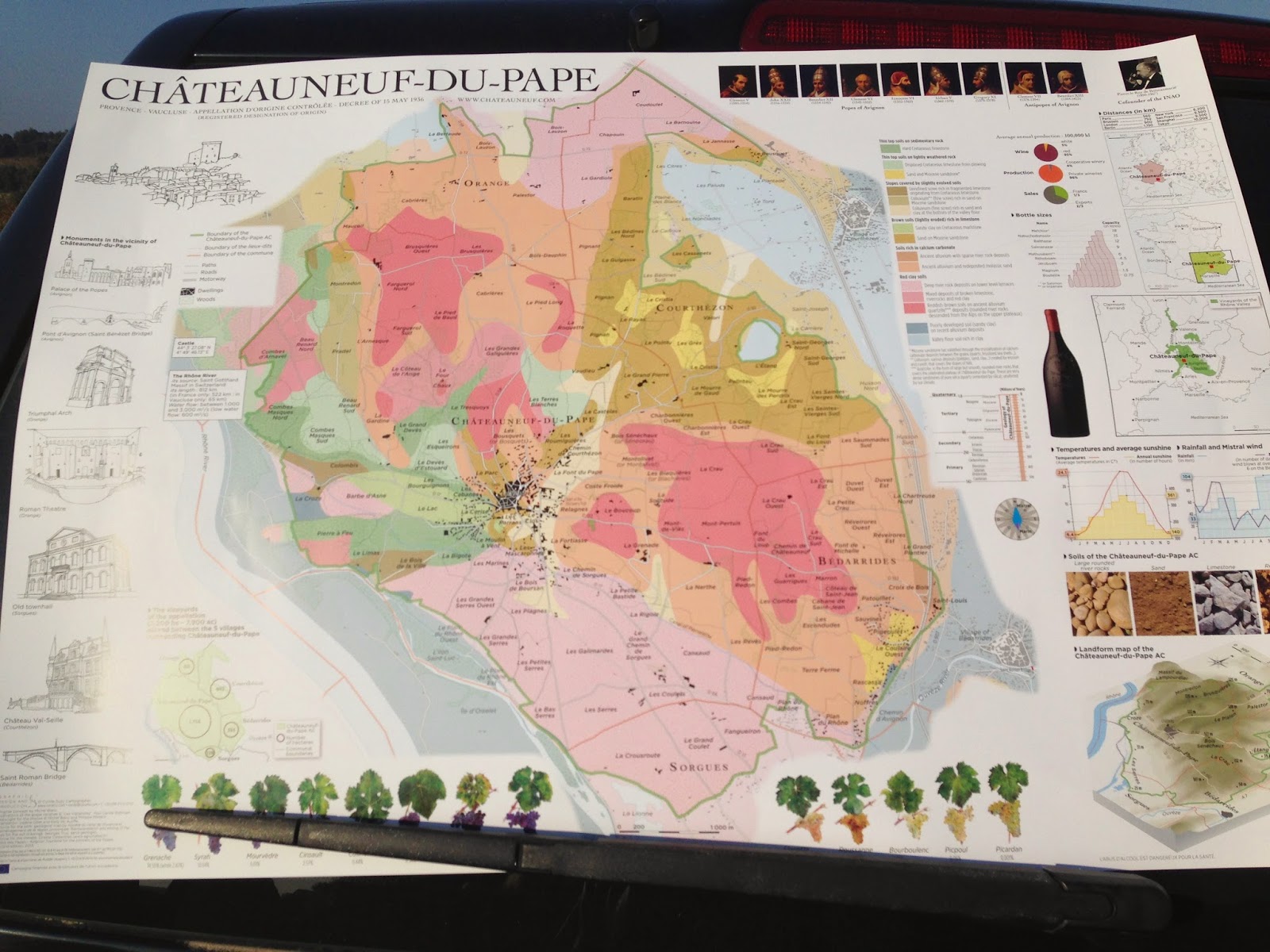
Landscape formation and the soils of Chateauneuf-du-Pape

The iconic view of Chateauneuf-du-Pape (CdP) is of gnarled vines rising out of a landscape comprised of smooth, rounded stones; stones, we are told, that aid in the ripening of grapes by capturing heat during the day and releasing it back into the environment at night.

I have always wanted to hold some of these stones in my hand and got the opportunity back in October of 2014 when I was honored to be among a group of bloggers invited by the Fédération des Syndicats de Producteurs Chateauneuf-du-Pape et Tavel to visit the region as part of a DWCC 2014 pre-Conference trip. The trip included one day in Tavel and one day in Chateauneuf-du-Pape and one of the highlights was the two hours spent in the CdP vineyards with geologist Georges Truc.

Today's post presents my understanding of the landscape formation and current soil conditions in Cdp and is based on the presentation of M. Truc as well as research conducted subsequent to the visit.


Geologist George Truc with KelleyMcAuliffe in background

In attempting to build a view of the formative influences on CdP, I have previously posted on the geology of the Rhone Valley as well as the landscape of the Northern Rhone sub-region. The Southern Rhone can itself be divided into two geologic spaces comprised of the Cotes-du-Rhone appellations and the communal appellations. While focused on CdP, a lot of the geologic effects are similar for areas such as Lirac and Tavel, for example, and can stretch as far east as Gigondas.


At the beginning of the Miocene (about 24 million years ago), the area that now constitutes the AOCs of CdP, Tavel, and Lirac were a part of the Urgonian limestone peaks of which modern-day Plateau du bois de Saint Victor, and the series of limestone buttes that are visible as you approach CdP, are a part. The portions of the limestone peaks between Lirrac-Tavel and Gigondas were submerged by the Miocene and Pliocene seas and overlain by sandy molasse and sand as a result (Fanet, Great Wine Terroirs).

The uplifting of the Alps displaced a lot of material which the Rhone carried down into the areas identified in the foregoing. Successive glacial periods resulted in the Rhone down-cutting into the existing landscape leaving stony terraces at different heights, with each terrace being named after the glacial period in which it was formed. The major CdP landscape-formative occurrences are tabulated below.

Period                 
Action/Occurrence   
Result
Early Tertiary Period
(66 - 37 My)
  • Limestone rock peaks emerged from the vast plain
  • Saint-Genies Mountain and Lampourdier Hill, remains of the coral reef that bordered Vocotian Sea
Miocene and Pliocene
(24 - 2 My)
  • Mediterranean Sea floods the Rhone Valley on two occasions
  • At max height covers all land masses except Saint-Genies Mountain
  • Thick layers of marl and sand laid down on sea floor
Pliocene
(5 - 2 My)
  • Considerable erosion in Alps
  • Rhone and tributaries carry vast amounts of fine and coarse gravel down stream
  • As river varies its course from west to east, a thick layer of gravel and stone covers the Miocene sands
Early Quaternary
(2 - 1 My)
Temperature drop in the glacial Riss stage
  • Seawater transformed into glaciers
  • Sea levels drop, encouraging the down-cutting of the Rhone through the Miocene sands
Late Quatenary
(1 - 0 My)
Glacial phase in two stages
  • Excavation due to cooling
  • Aggradations of large rounded pebbles due to warming
  • Limestone massifs prevent clearing of downstream deposits
Present Day
Fine alluvial soil deposited on the riverbed and surrounding plain

MY = Millions of years. Data sourced from Karis, The Chateauneuf du Pape Wine Book.

In his discussion about the soils, M. Truc indicated that there were three principal soil types in CdP and we drove to each of these in order to observe and be provided with the appropriate background. The first soil type that we drove to was on the east side of CdP and was described by  M. Truc as calcaire (limestone), that had been laid down in the Cretaceous period (145 - 66 million yeras ago). The limestone here is eroded and is the same age as the limestone encountered in Tavel. This soil is, according to M. Truc, best suited for whites as it imparts a salinity and minerality. It is not as well suited for reds as the tannins are not that evident and they do not realize the same power as the other terroirs.

The vines try to grow through cracks in the limestone, some of which (the cracks, that is) are filled with clay minerals. There are clay-based soils below the limestone. Clay is a very important part of any winemaking soil in France as it is key to provision of mineral to the vines


In describing the soils of the high terraces, M. Truc indicated that they were made from quartzite and had been deposited by the Rhone around 1.8 million years ago during the Quaternary period. Below the stones there are a variety of soils. Granite and gneiss were the original deposits in the Rhone region but extreme weathering dissolved the limestone and destroyed the granite leaving only quartz. Silica and feldspar was liberated from the quartz and formed clay. In the upper layers it manifests as brown soil. If you go further, it becomes red soil, and, even further, black mica.

The stones drain water and extends the heat of the day into the night. Powerful wines are produced from vines grown on these stony soils. Here vines are planted at between 2500 and 4000 vines per ha.


Most of the limestone in CdP has been covered by sand or clay with the most sandy region being to the east and being a product of the Miocene era. According to M. Truc, a lot of the sand is as a result of deposition of erosion from the Alps. Sandy soils had not been considered a good winemaking terroir untill recently but is now home to some of the finest, most elegant wines as, according to M. Truc, evidenced by the wines of Chateau Rayas and Clos du Caillou.

The map shown above has been modified to align the descriptors with the soils map shown earlier.


A description of the CdP wine region will be presented in a later post.


©Wine -- Mise en abyme

Sunday, January 4, 2015

The soils of Tavel AOC (Southern Rhone), the Rosé wine region

Tavel, illustrated by the red oval in the map below, is at once the solitary Rosé-only AOC in the French appellation system and (maybe because of that fact) the country's most famous Rosé. I visited the region as part of a DWCC2014 Pre-Conference Press Trip in October and will be sharing my experiences beginning with this post's discussion of the soils of the region.

Source: technoresto.org

The Tavel AOC encompasses the vineyards in the communes of Tavel and Roquemaure, with said vineyards planted on one of three distinct soil types: sandy, Lauses, or smooth pebbles.

Sandy Soils
The lowest part of the macro-vineyard is located on sandy soils dating from the Miocene and Pliocene eras (Jacques Fanet, Great Wine Terroirs, UCP, 2004). The sea, which had covered the region during the Cretaceous period, returned during the Miocene and Pliocene periods leaving thin deposits of clay and sands at the bottom of the slope (James Wilson, Terroirs, 1998; musee-boissons.com). The ancient Tavel vineyards were located on these sands which possess the following characteristics (Rolf Bichsel, Tavel: The People and the Wines, Feret, 2011):
  • Poor in organic matter
  • Visible portions consist of yellow, acid, decarbonated coarse sand and pebbles from the surrounding Villafranchian terraces
  • Clay at 30-cm depth
  • Bedrock (compressed Pliocene sands and non-decarbonated limestone sands) at 60-cm depth.
According to Bichsel, grapes grown in this soil produce wines with the lowest alcohol and highest yield of the three soil types and possess a strong aroma.


Lauses
This type is comprised of shallow soil covered with stone tiles mixed with red clay on a limestone bedrock. Heavy machinery is used to break up the top layer (60% limestone rocks). At 30-cm depth, 90% of the soil consists of rocky debris and marly limestone supplemented by a few pockets of clay. Bedrock begins at 60 cm and is comprised of solid limestone with slight cracking.

This area is 300 ha in size and is the hardest of the Tavel soils to cultivate. It is the most arid and poorest with the paucity of surface or near-surface water and nutrients driving the vines to create deep and extensive root systems (Bichsel).

Grapes grown on this soil produce wines that have (Bichsel):
  • High minerality
  • Finesse
  • Low yields
  • Fruity aromas.


Smooth Pebbles
Throughut our visit to Tavel and Chateauneuf-du-Pape, the team had recurring discussions as to the proper nomenclature for the polished stones synonymous with this region. Many members of the team, especially the American bloggers, could not bridge the gap between the images conjured up in their minds by the word pebble and the actual size of these stones.

According to musee-boissons.com, in the Villafranchian period (1.9 to 1.8 million years ago), powerful rivers with immense force were generated by the melting glaciers and pushed the rocks in their path for hundreds of kilometers, polishing them along the way until they became the smooth pebbles found in Tavel, Lirac, and Chateauneuf-du-Pape today. In Tavel, these pebbles are found in an area of the vineyard called Vallongue, an integral part of the Villafranchian terraces that stretch from Chateauneuf-du-Pape to Nimes (Bichsel).

Seventy-five percent of the subject soil consists of these large, rounded pebbles which can range in size from 10 to 40 cm in diameter. The pebbles are, generally (Bichsel):
  • Smooth and silky
  • Reddish and ochre in color
  • Mixed with whole blocks of stone and quartz sands
  • Range in depth from 5 and 15 meters
  • Flanked, intermixed, or covered with more recent strata of alluvial soil.
The most striking characteristics of this soil type are (i) the accumulation of heat during the day and its release at night (an aid in grape ripening) and (ii) its excellent drainage which, in turn, forces the vines to develop deep, extensive root systems.

Wines made from grapes grown in this soil are powerful and vinous, exhibiting great body, alcoholic strength, and structure (Bichsel).


Further posts in this series will detail the remaining terroir aspects of Tavel AOC as well as its viticulture and viniculture before switching to a similar treatment of the Chateauneuf-du-Pape AOC.

©Wine -- Mise en abyme

Tuesday, August 26, 2014

Construction of the Rhone wine region landscape

I have been selected to participate in a Press Trip to Chateauneuf du Pape and Tavel prior to DWCC14. I will, of course, be reporting on my findings both during and after the trip but, in keeping with my blog's mantra of "a story within a story," I will set the stage by describing, in ever-tightening circles, the environments within which the winemakers of those two regions operate. I begin here with the outermost circle, landscape formation in the Rhone River Basin, the broader region within which these two appellations are located.

Source: grid.unep.ch
The Rhône wine region runs along its namesake river for 250 km (150 miles) -- and 6 departèments -- between Lyon in the north and Avignon in the south with a division into northern and southern sub-regions at the point where the Drôme tributary intersects the main course. The Northern Rhône is characterized by a continental climate, granitic soils, steep slopes, and the mistral (a high-speed --140 km/90 miles per hour -- north wind that is funneled between the Massif Central and Vercors when there is high pressure over northern France and low pressure in the western Mediterranean) while the south has a more Mediterranean climate, the marin (a moist sea wind), and stony soils. What they both have in common, though, is a sea of red wine: only 2% of the region's production is white.

The Rhone Valley is a sedimentary basin but, unlike the expansiveness of its two better-known compatriots (Paris and Aquitaine basins), it is corridor-like and tightly bound between the unflinching basement rock of the Massif Central to its east and the younger rocks of the Alps to its west (Fanet, Great Wine Terroirs).


I have treated the formation of the Massif Central in my comparison of Douro and Beaujolais granite and schists. Suffice it to say that it was part of a vast mountain range (The Hercynian Mountain Belt) stretching from Britain to Eastern Europe which was formed as a result of a continental collision which ended 200 million years ago. This range has been severely eroded over millennia and in many places only exist as "basement" rock, hidden from view by sedimentary deposits. The figures below show the distribution of cover and basement rocks in current-day France as well as the composition of the varying rock types.

Basement and cover rocks of France.
Source:http://www.virtual-geology.info/lozere/lozere.html

Relationship between basement and cover rocks.
Source: http://www.virtual-geology.info/lozere/lozere.html
Formation timeline -- basement and cover rocks
Source: http://www.virtual-geology.info/lozere/lozere.html

The table below catalogs a series of events from the Lower Cretaceous onwards which have had contributory effects to the current Rhone Valley landscape. The figure immediately following shows the geologic construct of France as a whole and, outlined in black, that of the Rhone River Valley.

Period
Action/Occurrence
Result
Lower Cretaceous
(135 - 96 My)
Reef limestone deposited on continental platform surrounding Vocontian Trough (deep undersea area south of today's Valence)
Hard limestone hills now surrounding the Rhone Valley
Upper Cretaceous
(96 - 65 My)
  • Vocontian Trough filled with sandstone/sandy limestone/marly-sandstone
  • First phase of folding in Provence due to uplift of Pyrenean-Provençal axis (through end of Eocene)
  • Formed right bank of Rhone, Tricastin, and Massif d’Uchaux
  • Forced the Jurassic and Cretaceous cover northward
Oligocene
(36 - 24 My)
Thick deposits of conglomerates, sandstones, limestone accumulated in the foothills of the young hills
Rhone Valley axis collapsed
Miocene
(24 - 5 My)
  • Sea used the Rhone Valley as a corridor to link up to sea covering Central Europe
  • Alpine uplift reaches a crescendo
  • Sands, marly sands, sandy molasse deposited
  • Rhone digs itself through Miocene deposits as well as Urgonian limestone (formation of the Donzère defile)
  • Carves deep gash in basement granite north of present-day Tain l'Hermitage
  • Raising of the region along its eastern border
Pliocene
(5 - 2 My)
  • Final marine incursion
  • Deposits of fine argillaceous and argillaceous-sandy elements
Quaternary
(2 -  My)
Erosion changed the look of the landscape
  • Rubble and scree built up in the piedmont of the Urgonian limestone hills
  • Four levels of stony terrace systems formed along the Rhone and tributaries
MY = Millions of years. Data sourced from Fanet, Great Wine Terroirs.


The types of soils present in, as well as the location of, vineyards are a result of these landscape formation activities. In a follow-up post I will detail the vineyards and their soils.


©Wine -- Mise en abyme

Tuesday, June 18, 2013

Minerality in wine? Fuggedaboudit

Or so says Alex Maltman of the Institute of Geography and Earth Sciences, Aberystwyth University, Wales.

In a previous post, I outlined a battle revolving around the role of soils in wine quality/typicity. Alex Maltman (Role of Vineyard Geology in Wine Typicity, Journal of Wine Research 19 (1), 2008) noted that it had become de riguer, when describing a vineyard, to specify its geology and this, coupled with the geological indications common in tasting notes, has served to infer "... a direct link between the vineyard substrate and the resulting wine." According to Maltman:
Such perceptions bolster a valuable tactic for the wine trade, as, being one of the few aspects of wine production that cannot be translocated or easily replicated elsewhere, a vineyard's geology is something that can be invoked to promote a wine's typicity, to give it a marketable uniqueness.
In a follow-up article (Minerality in Wine: A geological perspective, Journal of Wine Research, 2013), Maltman has honed in on minerality, a thoroughly modern (according to him) invention which had received no mention in the works of the "masters" (Peynaud 1987, and Vine 1997, for example) or the science-based tasting schemes (Jackson 2009 and Noble et al., Aroma Wheel 1987, for example). Maltman's 2008 and 2013 articles are built around a similar core argument but in the 2013 article, in addition to focusing on minerality, he advances explanations as to what tasters could be confusing with minerality. The latter aspect of his research will be dealt with in a later post.

There is, in general, a lack of understanding of the differences between minerals in foodstuff (of which wine is a part) and geological minerals (Maltman).


While it is true that the vine plant needs a variety of mineral nutrients, and that weathered bedrock is the source of much of these nutrients, the path from geological mineral to nutrient mineral is a protracted, rocky, and time-variant road.


To illustrate the latter point, Maltman uses the example of feldspar, the most commen geological mineral resident in modern vineyards. Feldspar is a family of minerals containing various combinations of minerals that are "ionically and covalently bonded into a crystalline lattice that gives a grain of feldspar strength and rigidity." This feldspar particle is bound together with a number of other mineral grains to form the aggregate we call rock or, in its fractured form, stone. The minerals contained in feldspar are not directly accessible by the vine plant. To be accessible by the plant the minerals have to be ionic and in solution. The process of transformation from the geological mineral feldspar to vine-accessible mineral nutrients is illustrated below.

Source: geology.csupomona.edu

Source: letslearngeology.com
The gulf between the vineyard chemical profile and that of the wine is further widened as a result of vine activity. The amount of nutrient ions absorbed by the vine roots is not directly related to the amount of nutrient ions in the soil. Rather, it is dependent on the transportation proteins and cell wall hydrophobic deposits among other factors. Further, once in the xylem, differential amounts of ions are directed to the various components of the vine architecture. Even within the berries there is a differential allocation of ions between, skin, seeds, and juice (Maltman 2013).

The disconnect grows even wider once cellar activities commence (shown below) and, as a result, the "proportion of mineral nutrients in finished wine bears only a complex, indirect, and distant relationship with geological minerals in the vineyard" (Maltman 2013).


After establishing a less-than-tenuous relationship between vineyard minerals and the mineral-nutrient signature of the finished wine, Maltman goes on to argue that minerality, as such, cannot be tasted in a wine. First, he argues, the concentration of inorganic material, in general, and mineral elements, in particular, in wine is miniscule -- between 0.15 and 0.4% for inorganics and very low levels for the mineral elements. Of the minerals, potassium has the largest concentration at 577 ppm (.06%) while calcium ranges between 30 and 200 ppm and magnesium registers at .005 ppm. Of the 50 organic elements identified in wine, 25 are trace elements (1 - 100 ppm) while 20 are ultra-trace (parts/trillion).

Compounding their relative scarcity in wine, these mineral elements have no flavor, a situation that also holds for geological minerals which are both solid and insoluble. Flavor-detecting organs in the mouth can only deal with solutions thus only sodium chloride, of all the geological minerals, registers a flavor in the mouth (Maltman).

So mineral nutrients resident in wine occurs in small amounts and are lacking in flavor. Vineyard geological minerals are flavor-free and would not register a taste in the human mouth. Aroma, the other component of flavor, requires volatilization in order to register on the organs on the olfactory bulb but neither rocks nor minerals possess this capability. Minerality as a taste descriptor, then, requires a leap of faith on the part of the taster.

How about texture, you ask? The geological minerals that existed at the beginning of the journey have been transformed beyond recognition in that they now exist as ions, rather than compounds, and in extremely small quantities. Any minerality imbuing capability would have to survive the journey detailed above and still have enough "surviving energy" in order to "infect" the completed wine in such a way that it exhibits "minerality" in a uniform manner.

Does Maltman's analysis consign minerality to the scrap heap of taste descriptors? Let me know your thoughts.

©Wine -- Mise en abyme